Space Surveillance and Tracking
SpaceDyS has a strong expertise in both radar and optical data processing for orbit determination purposes in challenging situations. This allowed SpaceDyS to take part to key ESA and ASI studies regarding the surveillance of the space around Earth, which is the location where artificial satellites live.
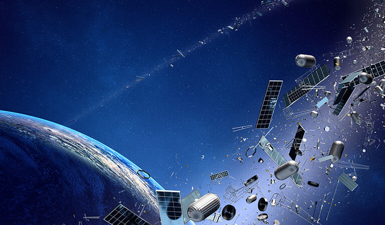
Over the years, the company has accumulated experience and skills for different aspects of space surveillance, from the cataloguing and tracking of man-made objects that now orbit like uncontrolled wreckage around the earth, to the reliable prediction of a satellite reentry.
Orbit Determination of Space Debris
A direct consequence of this inheritance was the participation of SpaceDyS in 2012 to the ESA study “CO-II – SSA Architectural Design”, within a consortium led by Deimos Space, about the architecture of a network of telescopes and radars for space debris observation and cataloguing. In this study SpaceDyS was in charge of simulating the processing of the optical data with the latest available orbit determination techniques for the construction of the catalogue of space debris.
The experience of the company in the orbit determination of space debris and satellites has grown further in the following years, through the work for different ESA and ASI studies. In addition to the CO-II project, the list of past and current studies and developments relevant for this topic comprises the following:
- The ESA study “SSA P2-SST-IV – Requirements Analysis for an Expert Centre for Federated Optical Observations”, performed in 2014, which aimed at the definition of the requirements for a centre collecting and processing the optical data coming from different already operational sensors observing Earth’s satellites.
- The ESA study “P2-SST-VII – Expert Coordination Centres (Phase I)”, performed in 2016, which was about the development of the software for the services of the Expert Centre.
- ASI study “Analysis on Software Tools for Space Debris Orbit Determination and Propagation”, which was the analysis of the capabilities and potential improvements of the orbit determination software of the italian consortium composed by SpaceDyS, IAPS-INAF, IFAC-CNR, and the University of Pisa. This study was performed for ASI in 2018.
- ASI study “SUTED – Studio dell’utilizzo del telescopio FlyEye per l’osservazione di detriti spaziali (Study on the usage of the FlyEye telescope for space debris observation)”, performed in 2020-2021, with leader OHB-I, in which SpaceDyS conducted simulations of the build-up of a catalogue of MEO objects using survey observations of a hypothetical network of 4 Fly-Eye sensors [L. Cibin, M. Chiarini, R. Pellegrini, F. Bernardi, L. Dimare, S. Cicalò, C. Marzo, A. Di Cecco, E. Perozzi, “SUTED – A detailed study for the application of the FlyEye telescope to the survey of the MEO orbital region” , Proceedings of the 8th European Conference on Space Debris, 20-23 April 2021, Darmstadt, Germany].
- ASI study “SUTED4LEO – Realizzazione delle attività di studio per l’applicazione del telescopio FlyEye per la
sorveglianza della fascia LEO (Realisation of the study for the application of the FlyEye telescope to the surveillance of the LEO belt)”, performed in 2022-2023 with leader OHB-I, for which SpaceDyS performed simulations of building and maintaining a catalogue of Low Earth orbiting objects using survey observations from a Network of Fly-Eye sensors [R. Pellegrini, P. Gregori, F. Cerutti, L. Dimare, F. Bernardi, D. Bracali Cioci, E. Vellutini, “SUTED4L- Study for the application of the Flyeye telescope to the survey of the high-LEO orbital region”, Proceedings of the 2nd ESA NEO and debris detection conference, 24 – 26 January 2023, Darmstadt, Germany]. - ASI project “Servizi inerenti alla realizzazione di un’infrastruttura HW e SW presso il CGS/Matera (Services regarding the realisation of an HW and SW infrastructure at the CGS/Matera)”, started in 2023 with leader Telespazio, currently on-going, for which SpaceDyS is developing many software modules, and in particular the entire Orbit Determination and Correlation Software, essential for the construction and maintenance of a catalogue of Earth orbiting objects using the data coming from a network of ASI sensors.
Thanks to inherited and new continuously acquired competences in this field, SpaceDyS DEBORB – DEBris ORBit determination software suite has been developed, improved and expanded. The current version includes advanced orbit determination and correlation algorithms to build-up a catalogue of space debris objects, even from scratch, from the processing of data acquired by an optical survey telescopes network. Moreover, the SW is able to maintain the catalogue through the processing of both survey and tracking observations. The processing of accurate range measurements coming from radar tracking is included.
DEBORB current version includes algorithms for:
- Initial Orbit Determination (in particular with methods of the Keplerian Integral class),
- orbit improvement with follow-up observations (both optical and radar),
- track-to-track correlation,
- track-to-orbit correlation,
- orbit-to-orbit correlation.
Fragmentation Analysis
Satellite breakups have already occurred in space, both from explosions and collisions. In order to be able to limit the increase of risk for the other active satellites, due to the release in orbit of additional uncontrolled debris from such events, it is necessary on one side to catalogue as much as possible the new pieces of debris generated, and on the other side to predict short and long term effects of any satellite fragmentation in orbit.
The cataloging step is covered by DEBORB orbit determination and correlation algorithms, provided that observations of the new debris are actually available from sensors.
The prediction of the consequences of a breakup can be obtained through:
- first, the analysis of already observed and possibly catalogued fragments for the reconstruction of the timing and type of event;
- second, the simulation of the generation of fragments through a software implementing a reliable breakup model.
For the first part of the activity, SpaceDyS has recently developed, as an internal research activity, a software module called In-orbit Fragmentation Analysis Tool (DebOrb FragAn module) for the reconstruction and characterisation of a fragmentation event on the basis of the orbital characteristics of a detected cloud of fragments [Dimare L., S. Cicalò, A. Rossi, E.M. Alessi, G.B. Valsecchi (2019). In-orbit fragmentation characterization and parent bodies identification by means of orbital distances, First International Orbital Debris Conference, 9-12 December, 2019, Sugar Land, Texas].
For the second part, the modelling of break-ups, SpaceDyS began many years ago with the development, as a basic reference tool, of its own software, called FragSim – Fragmentation Simulator, implementing the standard break-up model by NASA [Johnson et al. (2001) NASA’s new breakup model of evolve 4.0, Advances in Space Research Volume 28 Issue 9, Pages 1377-1384].
Between 2021 and 2022, SpaceDyS developed for ESA the tool COLBUSS – COLlision Break-Up Software System, implementing an adaptive statistical model for the simulation of the cloud of fragments produced after a collision in orbit [L. Dimare, A. Francesconi, C. Giacomuzzo, S. Cicalò, A. Rossi, L. Olivieri, G. Sarego, F. Guerra, S. Lemmens, V. Braun, “Advances in the characterisation of collision break-ups by means of numerical modelling”, Proceedings of the 72nd International Astronautical Congress (IAC), 25-29 October 2021, Dubai, United Arab Emirates.].
COLBUSS has been prototyped and tested during the ESA project “TDE-T711-603SD: Exploiting numerical modelling for the characterisation of collision break-ups”, led by SpaceDyS and performed in collaboration with CISAS – Centro di Ateneo di Studi e Attività Spaziali “Giuseppe Colombo”, University of Padua.
The tool works elaborating a new modelling for each event, obtaining it by interpolation, using as reference a database of known events. Such database was filled using the data obtained by an extended simulation campaign performed with a validated numerical tool for break-up simulations, namely the CSTS by CISAS-University of Padua.
The work with ESA is now going on in this topic with a new ESA project named “T711-802SD – On-Orbit Break-up Forensics”, led by Politecnico di Milano. The project aims to develop the prototype of a unified tool for the breakup reconstruction and analysis, able to provide to the scientists exhaustive information for prompt event assessment and for conducting an optimised campaign of fragments observation and characterisation.
For this project SpaceDyS is in charge of providing a software module able to calibrate the breakup models implemented in ESA software tools POEM and COLBUSS, on the basis of the acquired data related to a specific event.
Re-Entry Predictions
Uncontrolled decay of large LEO objects into the atmosphere poses a risk for people and infrastructures on ground. SpaceDyS can provide reliable predictions of re-entry time and location with the most accurate models available.
Collision Avoidance
The significant increase in the number of operational satellites in LEO led to the need for an efficient space traffic management. SpaceDyS is involved in the development of software and strategies to safely avoid in-orbit collisions.
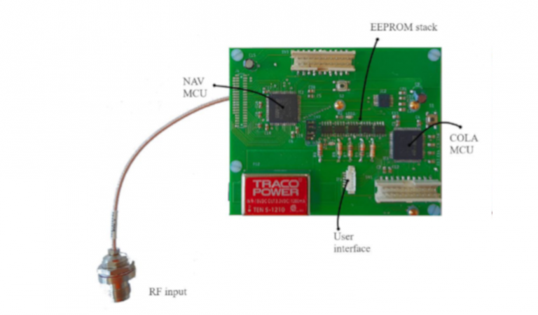
Through a ASI co-funding programme, SpaceDyS and the University of Bologna developed ABACO, a TRL4 Engineering Model based on COTS components, of an autonomous navigation system to be installed aboard satellites.
Such a system consists of a GNSS receiver coupled to a Navigation Computer with advanced capabilities for improved orbital determination, based on GNSS observables in real-time, allowing accurate predictions for the purposes of collision avoidance, orbital correction and maintenance. The Navigation Computer interfaces with a Collision Avoidance Computer integrated within the same device, which is responsible for estimating the probability of collision with another object and calculating the collision avoidance maneuver, if any, on its own.
Image Processing
- Detect trails down to SNR~1 per pixel
- Detect trails as long as 2000 pixels
- Process one single image within 10 seconds to be able to process the full data set within the start of the following observing run
- Deal with 16 cameras per telescope and being able to process more than half a Terabyte of data per night
- Reach astrometric accuracies down to 0.75 arcsec or better
- Time accuracy better than 1/1000 sec
- Very low false/true detections ratio
- Pre-processing: BIAS, DARK and FLATENING
- Source Detection: both stars (for astrometric purpose) and faint trails are detected
- Astrometric and Photometric Calibration: using background stars, each image is astrometrically and photometrically calibrated. The shutter encoder information is used to time calibrate the image
- Post-processing: final process to link cross images trails
- The SW final output is a TDM file with the astrometry and photometry of the detected trails, which will be uploaded to the orbit determination centre data processing system
Associates
DEBORB
Space DEBris ORBit determination software suite
ABACO
Autonomous Board for Avoiding COllisions
IMPRESS4FLY
Fly-Eye telescope image processing
AFFILIATIONS